


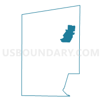
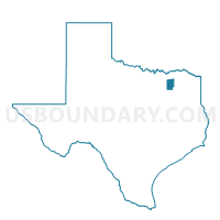
Voting District 0429, Hunt County, Texas
About
Outline

Summary
| Unique Area Identifier | 674935 |
| Name | Voting District 0429 |
| County | Hunt County |
| State | Texas |
| Area (square miles) | 26.15 |
| Land Area (square miles) | 26.01 |
| Water Area (square miles) | 0.14 |
| % of Land Area | 99.48 |
| % of Water Area | 0.52 |
| Latitude of the Internal Point | 33.22838200 |
| Longtitude of the Internal Point | -95.94205500 |
Maps

Graphs
Select a template below for downloading or customizing gragh for Voting District 0429, Hunt County, Texas


Neighbors
Neighoring Voting District (by Name) Neighboring Voting District on the Map
- Voting District 0427, Hunt County, TX
- Voting District 0428, Hunt County, TX
- Voting District 0430, Hunt County, TX
- Voting District 0432, Hunt County, TX
- Voting District 0433, Hunt County, TX
- Voting District 0436, Hunt County, TX
Top 10 Neighboring County Subdivision (by Population) Neighboring County Subdivision on the Map
- Greenville CCD, Hunt County, TX (35,498)
- Commerce CCD, Hunt County, TX (10,203)
- Lone Oak CCD, Hunt County, TX (5,666)
Top 10 Neighboring Place (by Population) Neighboring Place on the Map
Top 10 Neighboring Unified School District (by Population) Neighboring Unified School District on the Map
Top 10 Neighboring State Legislative District Lower Chamber (by Population) Neighboring State Legislative District Lower Chamber on the Map
Top 10 Neighboring State Legislative District Upper Chamber (by Population) Neighboring State Legislative District Upper Chamber on the Map
Top 10 Neighboring 111th Congressional District (by Population) Neighboring 111th Congressional District on the Map
Top 10 Neighboring Census Tract (by Population) Neighboring Census Tract on the Map
- Census Tract 9607, Hunt County, TX (5,666)
- Census Tract 9604, Hunt County, TX (4,835)
- Census Tract 9605, Hunt County, TX (3,955)
- Census Tract 9606, Hunt County, TX (3,877)
- Census Tract 9601, Hunt County, TX (2,371)